Navigation Pioneers in Electromagnetic Deserts: Anti-Interference RTK and Multi-Source Fusion Positioning Algorithms
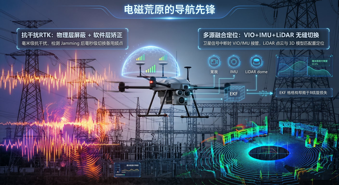
In complex industrial environments, the primary challenge for UAVs is not flight itself, but precise positioning under extreme electromagnetic interference. Traditional GNSS are highly susceptible to multipath effects and electromagnetic noise when close to high-voltage power lines or dense metal-structured chemical plants. According to research in IEEE Transactions on Aerospace and Electronic Systems, broadband noise from high-voltage electromagnetic fields significantly reduces the signal-to-noise ratio of carrier phases, leading to positioning drift. To overcome this, Likiu developed a deeply integrated anti-interference RTK system. This system relies not only on dual-antenna phase difference technology for centimeter-level precision but also on its electromagnetic shielding architecture and adaptive frequency optimization algorithms. When interference is detected in a specific frequency band, the system switches to a backup frequency in milliseconds. By utilizing real-time modeling and compensation for ionospheric and tropospheric errors, it ensures the flight path remains locked even in high-interference environments. This integration of physical-layer filtering and software-layer algorithmic correction provides a reliable digital coordinate system for stable UAV operations in industrial "no-go zones."
However, true "all-scene" positioning does not depend solely on satellites. When a UAV flies under bridges or into tunnels, satellite signals are severed. Consequently, our positioning logic has evolved into the "multi-source sensor fusion" stage, a strategy aligned with the "multi-modal environmental perception framework" proposed in the Journal of Field Robotics. The system fuses data from VIO, IMU, and LiDAR point cloud data in real-time. The moment a satellite signal vanishes, the flight control system seamlessly takes over, performing high-frequency sampling of ground textures via visual sensors and calculating precise relative displacement using six-axis gyroscope data. IMU acceleration data, processed through Extended Kalman Filter (EKF) algorithms, instantaneously compensates for visual feature loss in low-light environments. Simultaneously, LiDAR scans the surrounding environment, performing point cloud matching with pre-stored 3D models to complete absolute position re-localization. This "seamless switching" architecture eliminates single-point dependency, enabling the UAV to maintain absolute path precision through biological-like instinct.
For industrial applications, positioning stability is directly linked to mission success. During long-distance power line inspections, UAVs must maintain safe distances while capturing subtle defects in insulator strings. UAV's navigation algorithm introduces a deep learning-based dynamic weight distribution mechanism: the system automatically adjusts the fusion weights of satellite, visual, and inertial data based on confidence intervals. As noted in Nature Machine Intelligence regarding autonomous robots, system robustness stems from the adaptive processing of uncertainty. When strong winds cause jitter or ambient light changes abruptly, the system filters out noisy data and relies on the inertial core to maintain the path. This three-dimensional protection, from hardware shielding to algorithmic fusion, grants UAV UAVs industrial-grade certainty in extreme environments. This is a leap in the boundaries of autonomous operation, transforming the vision of "all-airspace free flight" into a quantifiable reality.