The Invisible Eye of Digital Farmland: Multispectral Sensing and Variable-Rate Precision Operation Systems
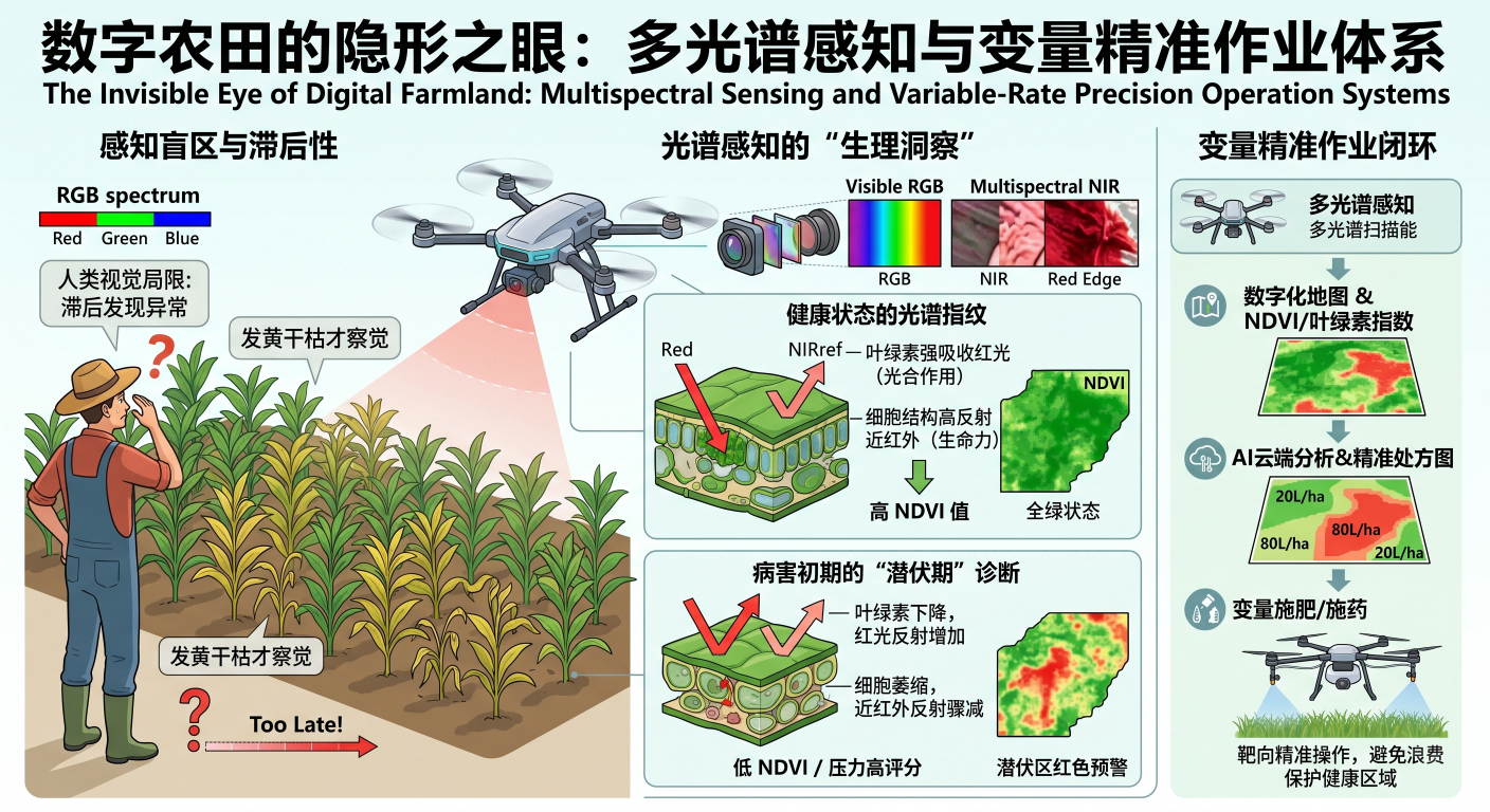
In the grand progression of modern agriculture toward digitalization, UAVs have undergone a magnificent transformation from simple "spraying machines" to integrated platforms for high-altitude remote sensing and prescription-based operations. The core of this revolution lies in the expansion of human perception of farmland from the limited visible light spectrum to an infinite array of spectral fingerprints.
Human visual observation of plants is confined to the visible light spectrum between 400nm and 700nm, specifically the Red, Green, and Blue (RGB) wavelengths. In this restricted perspective, agricultural management is often "lagging": typically, the naked eye can only detect abnormalities when crops show obvious yellowing, withered leaves, or large-scale lesions. However, physiological changes in plants often leave traces in invisible spectral bands several days before any external morphological alterations occur.
The internal cellular structure of plant leaves exhibits excellent selectivity for different wavelengths of light. Healthy mesophyll tissue, rich in chlorophyll, strongly absorbs Red light for photosynthesis while exhibiting extremely high reflectivity for Near-Infrared (NIR) light. This sharp contrast between "strong absorption" and "high reflection" constitutes a unique physical "fingerprint" of plant vitality. When a UAV equipped with multispectral sensors flies over farmland, it is essentially recording subtle shifts in these physiological fingerprints.
By capturing data in bands such as Red, NIR, and Red Edge, technicians can calculate the Normalized Difference Vegetation Index (NDVI) or chlorophyll indices. If crops suffer from pests or malnutrition, their chlorophyll content drops, causing an increase in Red light reflection; simultaneously, the shrinking of cellular structures leads to a sharp decline in NIR reflection. These drastic fluctuations in spectral response allow UAVs to issue digital warnings during the early stages or even the "incubation period" of a disease outbreak.
However, merely "seeing" the problem is only the first step; the ultimate value of multispectral remote sensing lies in driving "Variable-Rate Precision Operations." This requires processing captured spectral data through radiometric calibration and orthorectification to generate high-precision digital maps. These maps are then converted into a digital "Prescription Map," dividing vast farmland into countless centimeter-level grids, each assigned differentiated fertilizer or pesticide dosage instructions.
Guided by RTK technology, the operational plant protection UAV can achieve centimeter-level path accuracy. When the UAV enters a "healthy" zone, the flight control system automatically reduces nozzle pressure; upon entering a "distressed" grid, the system responds instantaneously to increase flow. This closed-loop system not only improves pesticide utilization by over 30% but also establishes digital archives for farmland, propelling agriculture toward a truly industrialized, data-driven model.