Embroidering in Turbulence via the "Satellite Lock"
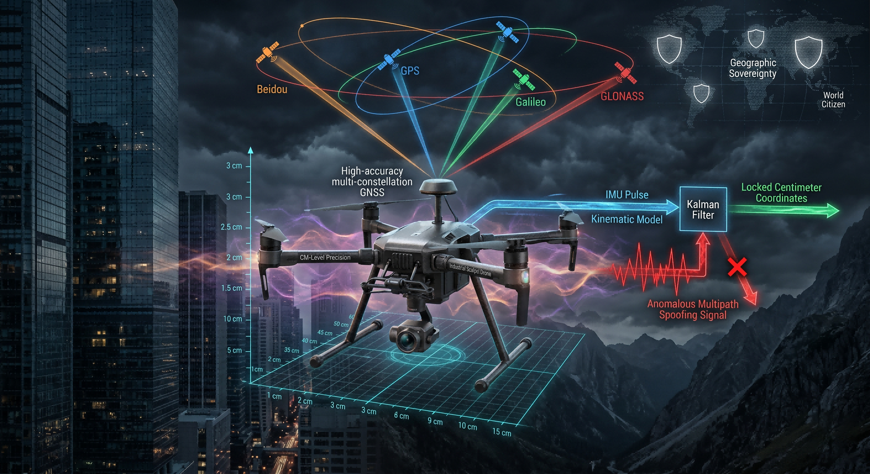
In the general public's perception, a drone's positioning in the air is merely about "staying still." However, from the microscopic perspective of physics, that seemingly calm low-altitude space is actually a maelstrom of undercurrents. We must understand that a drone with a net weight of less than one kilogram is essentially a precision integrated body constantly countering disturbances within a 3D chaotic system. The instantaneous crosswinds generated by the venturi effect between high-rise buildings can reach speeds of over ten meters per second; invisible electromagnetic fields emanating from substations or high-voltage cables are constantly attempting to push this lightweight mechanical body off its intended course through physical thrust and electronic noise. For a drone solely dependent on the Global Navigation Satellite System (GNSS), maintaining stability is not a static "result" but a relentless, high-frequency "algorithmic gamble" occurring hundreds of times per second, consuming immense computational power.
This is precisely why modern industrial drones must pursue "multi-mode navigation." Early drones might have relied solely on GPS; once they entered complex terrain like a valley between two mountains or operated in financial districts with towering skyscrapers, obstructions overhead would rapidly reduce the number of available satellites. When the number of visible satellites drops below four, the mathematical trilateration positioning model collapses. However, the current "quad-constellation" fusion (BeiDou, GPS, Galileo, GLONASS) has completely transformed this situation. This is not just a simple addition of numbers; it is more like a "celestial choir" spanning Earth's orbits and involving the aerospace prowess of different sovereign nations. When a drone performs power line inspections deep in a valley, even if the terrain obscures 70% of the sky, the multi-mode fusion algorithm allows it to "handpick" the most ideally positioned twenty-plus satellites from the global four major systems through the narrow gap overhead. This redundancy is the baseline for industrial operations: it ensures that positioning accuracy does not slide from "centimeter-level" to "street-level" due to the drift of a single satellite or the limitations of a single system.
However, receiving signals is only the first step; the true hardcore challenge lies in the microsecond after the signal arrives—solving "multi-path effects" and signal spoofing. In modern reinforced concrete forests, satellite signals do not reach the receiver in a straight line; they bounce off glass curtain walls, metal roofs, and even water surfaces. These delayed bounce signals can mislead the calculation chips, making the drone believe it has a pose deviation that doesn't exist. At this point, software-level "intelligent analysis" becomes an invisible helmsman. The Kalman filter algorithm plays the role of a "prophet" here. It establishes a sophisticated kinematic mathematical model that not only compares the coordinates provided by satellites in real-time but also constantly monitors the pulse of the internal Inertial Measurement Unit (IMU) and gyroscopes. If the satellite signal suddenly provides an anomalous data point suggesting an "instantaneous displacement of a hundred meters," the algorithm will coldly judge this as a false signal based on the airframe's acceleration cosines and the laws of conservation of angular momentum, instantly discarding it. This "almost paranoid" verification of data allows the drone to remain firmly nailed in the void even in industrial areas with heavy electromagnetic interference and extremely fragmented signals. For power line inspectors, this algorithmic resilience means they can confidently maneuver the drone close to high-voltage induction coils carrying tens of thousands of volts without fear of a catastrophic collision caused by signal jumps.
The deeper significance lies in the fact that this navigation resilience, based on the extreme extraction of GNSS capabilities, effectively grants the drone a form of "geographic sovereignty" and "mission independence." In missions involving cross-border search and rescue, polar scientific expeditions, or energy security along the "Belt and Road," drones are no longer restricted by specific political boundaries or technical fluctuations of a single navigation system. It is a true "global citizen," obtaining consistent and reliable accuracy endorsements at any coordinate point on Earth. This leap from simple reliance on hardware sensitivity to algorithmic intelligence and global system fusion is the first step for low-altitude civilization toward standardization. Only when positioning is no longer the Sword of Damocles hanging over developers can drones truly evolve from "flying cameras" into "flying precision scalpels," carrying out complex physical intervention tasks ranging from 3D modeling to precision delivery.